PLEASE NOTE: Canada pages are currently being revised, so check back often for new maps, and more.

Description
Canada
is a massive land, and the second largest country on the planet. It
geographically and politically separates itself into (10) provinces and
(3) territories, each with an individual capital city.
Stretching across 6 times zones, it's home to vast mountain ranges, over two million lakes and dozens of important rivers.
Canada has 39 national parks, over 1,000 provincial parks and nearly 50 territorial parks.
From its vast wilderness areas and frontier towns, to the Great Lakes and the modern cities of the south, Canada presents one of the most unique destinations on the planet.
It's a proud, independent land that still maintains the flavor and
style of its long associations with the cultures of England and France.
Read more about the history and culture of Canada here.
Facts and Figures
 Official Name Canada Official Name Canada
Population 31,720,240
Capital City Ottawa (852,100)
City Populations (largest) here
Languages English (official), French (official)
Official Currency Canadian Dollar
Currency Converter
here
Religions Catholic 46%, Protestant 36%, others
Flag
here

Land
Land Area 9,220,970 sq km (3,560,217 sq miles)
Latitude/Longitude (Ottawa) 45� 42 N, 75� 71 W
Landforms here
Rivers here
Highest Point Mount Logan, 5,959 m, (19,550 ft)
Canada/U.S. Border 3,987 miles (6,415 km)

Africa | Antarctica | Asia | Australia/Oceania
Europe | Islands/Oceans | Middle East
North America | South America
World Atlas
Contact Us | Privacy Statement
Copyrighted 1996-2004 by Graphic Maps
All rights reserved!
All
maps, graphics and original descriptions created by Graphic Maps, a
d/b/a of the Woolwine-Moen Group, unless otherwise noted and/or
directly linked to the source, and use of same for any application
whatsoever (with the exception of outline maps) requires written permission.
We make no copyright claim on any statistical data on this page, nor on
any non-original graphics, and/or pictures not produced by us. Certain
statistical data is gathered from the CIA World Factbook, as well as numerous public domain reference materials.
Every effort is made to be as accurate as possible when disseminating
information on any worldwide destination. We are not responsible for
unintentional data entry errors or omissions. If you would like to
submit an addition, change or correction, or suggest a new link, please
forward it to our map department and we will give it our immediate attention.


|
|

|
Maps
Canada Outline Map here
Canada Capital Cities here
Canada Landforms Map here
Canada Maps at UT here
Canada Map CIA version here
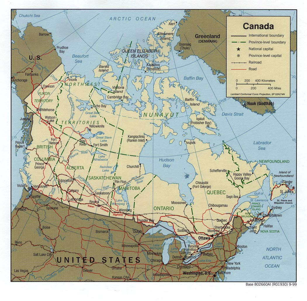
Canada Political Map Lambert Projection here
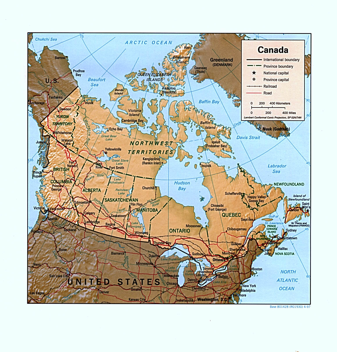
Canada Relief Map Lambert Projection here
Canada Provinces & Territory test
and answers, here
North American Continent here
Questions
Question about Canada? Ask it
here!

Suggested Links
Canada
(Complete) information on the (GDP) overall economy, imports and
exports, resources, government, population, military, transportation,
and more here!
Canada's official web site
Canada Info Pages official web site
Canada Travel here
Canada's VIA Railroad
Canada Time Zones here
Montreal Web Site here
Ottawa (Capital City) info here
Toronto Web Site here
Vancouver Web Site here
Time and Weather
Times across Canada here!
 Time and Date in Ottawa Time and Date in Ottawa
|
|
|
Provinces and Territories

Alberta
British Columbia
Manitoba
New Brunswick
Newfoundland & Labrador
Nova Scotia
Nunavut Territory
Northwest Territories
Ontario
Prince Edward Island
Quebec
Saskatchewan
Yukon Territory
North America
Canada
Caribbean
Central America
Mexico
North America
United States
Provinces and Territories
Alberta
British Columbia
Manitoba
New Brunswick
Newfoundland & Labrador
Nova Scotia
Nunavut Territory
Northwest Territories
Ontario
Prince Edward Island
Quebec
Saskatchewan
Yukon Territory
|

